Escalante Valley
Maps
| Utah Variance Areas |
Escalante Valley SEZ |
 |
 |
|
|
|
SEZ Analysis
The Escalante Valley solar energy zone (SEZ) is located in Utah in the Escalante Desert. The SEZ is located on BLM-administered land within the Cedar City Field Office.
Size and Location
The Escalante Valley solar energy zone (SEZ) has a total area of 6,614 acres (27 km2). In the Supplement to the Draft Solar PEIS, 12 acres (0.05 km2) of dry lake area and 69 acres (0.28 km2) of dune area were identified as non-development areas, leaving the SEZ with a potentially developable area of 6,533 acres (26.4 km2). No additional changes to the SEZ developable area were made in the Final Solar PEIS.
The Escalante Valley SEZ is located in Iron County. The SEZ lies in the south-central portion of the Escalante Desert, bounded by Mineral Mountains to the northeast, Black Mountains and the Antelope Range to the south and southeast, and Shauntie Hills and Wah Wah Mountains to the northwest. In 2008, the county population was 45,833, while adjacent Washington County to the south had a population of 148,256. The largest nearby town is Cedar City. Several small towns are located closer to the SEZ.
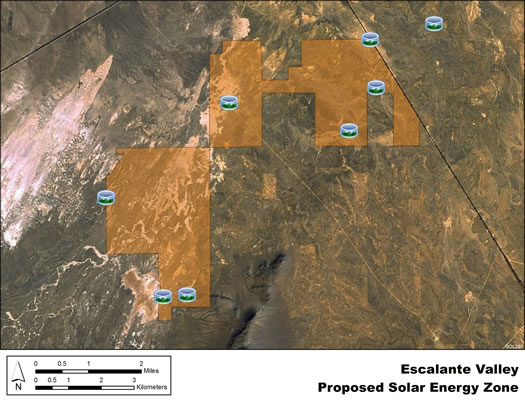
Escalante Valley SEZ
(does not show non-development areas)
Physical Characteristics
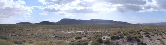
Land within the Escalante Valley SEZ is undeveloped scrubland characteristic of a high-elevation, semiarid basin. An area of low dunes is located in the western portion of the SEZ, where there is slightly more relief and large expanses of sand.
A number of unpaved roads cross the SEZ. The land within the SEZ contains livestock ponds (typically dry), cattle trails, and wire fences. No electric transmission lines are located within the SEZ. Part of the SEZ is authorized by the BLM for grazing. The SEZ may be used by local residents for general outdoor recreation, including backcountry driving and off-highway vehicle use, recreational shooting, and small and big game hunting.
Distant mountains surround the SEZ. The Union Pacific Railroad is northwest of the SEZ and a spur passes just to the northeast. There are also transmission lines and a few low structures east of the SEZ.
Technical Suitability
The nearest major road is State Route 56, about 15 mi (24 km) south of the SEZ. Access to the Escalante Valley SEZ is via county road; Lund Highway passes northeast of the SEZ. A 138-kV transmission line ends about 3 mi (5 km) from the southernmost part of the SEZ. As of May 2012, there were no pending solar applications within the SEZ.
|