
|
 |
Priority Development Area (Solar Energy Zone) and Variance Area Maps
View maps showing BLM-administered lands available for solar energy development as identified in the Solar PEIS Record of Decision, including maps of the 17 solar energy zones (SEZs) and the variance areas.
Who Should Use these Maps and Why
These files provide all users with fast, easy access to downloadable maps of the lands potentially available for solar energy development as identified in the Solar PEIS Record of Decision, in Adobe Acrobat format. These non-interactive maps contain a large amount of data that can be used by anyone; are easy to download, view, or e-mail; and can also be used to create high-quality printed output. Because the data used as the basis for these maps has not been updated or expanded since publication of the Final Solar PEIS, the maps provide a "snapshot" of data used for the PEIS.
Solar Energy Zones
The 17 SEZs are priority development areas for utility-scale solar energy facilities. An SEZ is an area well-suited for utility-scale production of solar energy where BLM will prioritize solar energy and associated transmission infrastructure development. A discussion of the criteria used to identify the SEZs is provided in Chapter 2 (Volume 1 of the Final Solar PEIS). Detailed information on the SEZs is provided in Chapters 8 through 13 of the Final Solar PEIS.
Maps of Individual SEZs
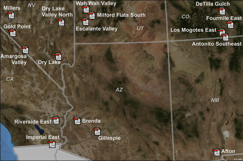
The following maps show individual SEZs and the surrounding areas. The maps include the boundaries of the SEZs and non-development areas within the SEZs (if applicable), as presented in the Final Solar PEIS and incorporated into the Solar PEIS Record of Decision. The maps also show the original boundaries of the SEZs as proposed in the Draft Solar PEIS.
|
Arizona
California
|
Colorado
Nevada
|
New Mexico
Utah
|
PLEASE NOTE: More information about the SEZs, including interactive maps, photo panoramas, and descriptions of each SEZ, is available in the Solar Energy Zones section of this Website.
Land Use Allocations for Solar Energy Development
Thirty-two categories of lands are excluded from solar development through the Record of Decision for the Final Solar PEIS (see Record of Decision, Appendix A, Section A.2). The geographic boundaries for exclusion categories 13, 14, 28, 29, 31, and 32 are explicitly defined through the Record of Decision and its associated maps. The remaining exclusion categories are defined by the presence of a specific land use designation in an applicable land use plan (e.g., Areas of Critical Environmental Concern, exclusion category 3) or the presence of a specific resource or condition (e.g., designated or proposed critical habitat for ESA-listed species, exclusion category 4). The geographic boundaries for such exclusion categories will change over time as land use plans are revised or amended and new information on resource conditions is developed.
For the purposes of the Solar PEIS and its associated NEPA analysis, the BLM has mapped and estimated the acreage for exclusions in the aggregate based on best available existing information. Data were available to map the following exclusion categories:
- BLM-administered lands where development is prohibited by law, regulation, Presidential proclamation or Executive Order (i.e., lands in the National Landscape Conservation System [NLCS]),
- Lands having slopes greater than 5%,
- Lands with solar insolation levels less than 6.5 kWh/m2/day,
- BLM Areas of Critical Environmental Concern,
- Critical habitat for USFWS designated threatened and endangered species,
- BLM Right-of-Way Exclusion and Avoidance Areas,
- BLM No Surface Occupancy Areas,
- Special Recreation Management Areas (note these were not excluded in the State of Nevada or in a portion of the Yuma East SRMA in Arizona), and
- Greater sage-grouse habitat in California, Nevada, and Utah; Gunnison's sage-grouse habitat in Utah; and Desert Wildlife Management Areas, Flat Tailed Horned Lizard habitat, and Mojave Ground Squirrel habitat in California.
Exclusion areas that could not be mapped due to lack of data would be identified during pre-application consultations with local BLM staff or during site-specific evaluation of individual ROW applications. A detailed discussion of these and other exclusions is provided in Chapter 2 (Volume 1 of the Final Solar PEIS).
Specific areas were identified for exclusion from solar development by the BLM following the publication of the Supplement to the Draft Solar PEIS, these areas were identified on the basis of continued consultation with cooperating agencies and tribes to protect sensitive natural, visual, and cultural resources. These areas total 1,066,497 acres (4,316 km2), and are shown in the figure available below. A GIS layer for these exclusions is provided on the GIS Shapefiles page.
Maps of Land Use Allocations as a Result of the Solar PEIS Record of Decision
The following maps show the locations of BLM-administered lands in each state that (1) are not available for solar energy development under any circumstances (2) are exclusion areas identified through the Solar PEIS Record of Decision, and (3) are variance areas identified through the Solar PEIS Record of Decision. They also show the locations of the SEZs.
The maps require the free Acrobat Reader.
Map of FWS Identified Priority Desert Tortoise Connectivity Areas
The U.S. Fish and Wildlife Service (FWS) has identified certain areas within the proposed variance areas that may be important for desert tortoise connectivity (i.e., priority desert connectivity habitat). Recovering desert tortoises throughout their range requires that conservation areas be connected by habitat linkages in which tortoises reside and reproduce. Such areas will need to be free of large-scale impediments from anthropogenic activities that result in loss of habitat. A map of the priority desert tortoise connectivity areas and an explanation of how the areas were identified by the FWS are provided below; a GIS layer for the connectivity areas is provided on the GIS Shapefiles page. Developers that propose utility-scale solar energy projects in variance areas that overlap priority desert tortoise connectivity areas identified on FWS maps will be required to meet with the BLM and FWS early in the process as part of the previously mentioned preliminary meetings to receive instructions on the appropriate desert tortoise survey protocols and the criteria the BLM and FWS will use to evaluate results of those surveys. A detailed discussion of the required documentation is provided in Section 2.2.2.3 of the Final Solar PEIS (Volume 1).
Map of NPS Identified High Potential Resource Conflict Areas
The National Park Service (NPS) has identified areas within the variance areas where utility-scale solar development poses a high potential for conflict with natural, cultural, and/or visual resources administered by the NPS. A regional map of the NPS-identified high potential resource conflict areas is provided in the document NPS Identified Areas of High Potential for Resource Conflict – Regional and an explanation of how the areas were identified by the NPS is provided in the document Explanation of Resource Conflict Analysis Used to Determine NPS-Identified Areas of High Potential for Resource Conflict; a GIS layer for these areas is provided on the GIS Shapefiles page. Area-specific maps and descriptions of resource conflicts are provided in the document NPS Identified Areas of High Potential for Resource Conflict – Area Specific. Area-specific resource condition maps are provided in the document NPS Identified Areas of High Potential for Resource Conflict – Resource Condition Maps (294 MB). The BLM will utilize these maps and associated data in the screening of proposed solar energy projects in variance areas. In cases where a utility-scale solar energy development application is submitted in a variance area identified as having a high potential for conflict with the resources of a unit of the NPS or special areas administered by the NPS, additional documentation will be required. A detailed discussion of the required documentation is provided in Section 2.2.2.3 of the Final Solar PEIS (Volume 1).
|